


The National Center for Hydro-Meteorological Forecasting reported that at 9 a.m. on September 23, 2025, the center of Super Typhoon Ragasa (Storm No. 9) was located over the northern East Sea, with maximum sustained winds of 221 km/h, equivalent to Category 17, and gusts exceeding Category 17. Over the next three hours, the storm is expected to move west-northwest at a speed of 20 km/h.
As such, Ragasa has surpassed Typhoon Yagi from 2024 to become one of the strongest storms to traverse the East Sea in the past 30 years. The latest forecast models from this morning indicate that Ragasa is moving rapidly into the East Sea at an average speed of 20-25 km/h.
In terms of intensity, the storm will maintain super typhoon strength throughout the day and night of September 23. By 4 a.m. on September 24, while positioned over the northern part of the northern East Sea, approximately 450 km east of the Leizhou Peninsula (China), Ragasa will remain a super typhoon at Category 16-17, with gusts exceeding Category 17—comparable to the peak strength of last year's Yagi.
However, starting September 24, the storm will gradually weaken as its northern circulation begins to interact with the Chinese mainland. Forecasts suggest that by 4 a.m. on September 25, after passing over the Leizhou Peninsula and entering the Gulf of Tonkin, the storm will sustain winds at around Category 12, with gusts up to Category 15.
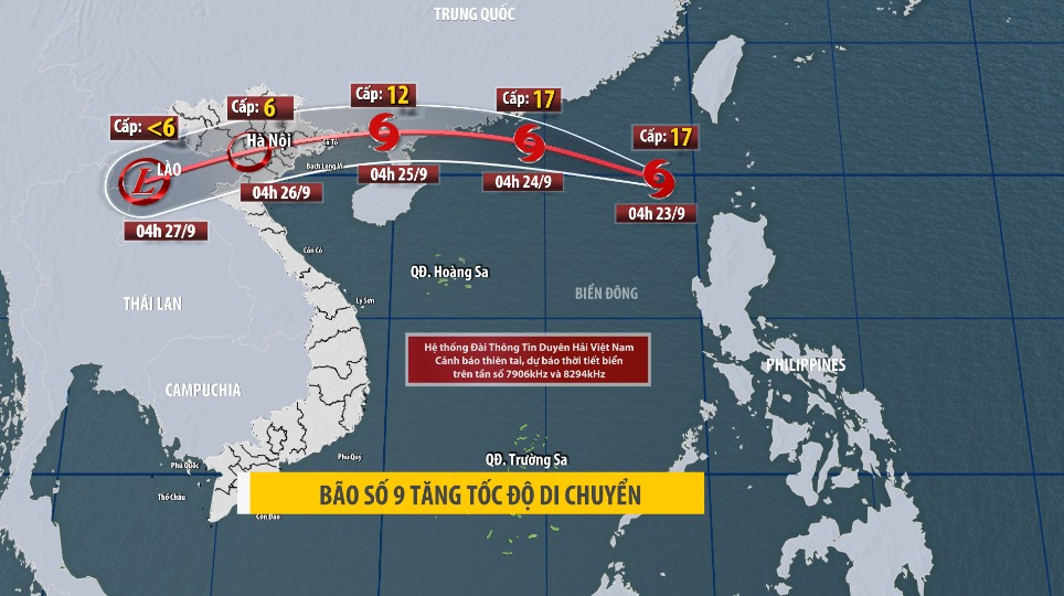
On land, in the early morning of September 25, coastal areas from Quang Ninh to Thanh Hoa will experience winds strengthening to Category 6-7, later escalating to Category 8, with areas near the storm's center reaching Category 9-10 and gusts up to Category 12. Deeper inland in the eastern North region, winds will reach Category 6-7, with gusts of Category 8-9.
At sea, the northern East Sea will see strong winds of Category 10-14, with areas near the super typhoon's path experiencing Category 15-17 and gusts exceeding Category 17, accompanied by waves over 10 meters; extremely rough seas.
From September 24, the eastern part of the Gulf of Tonkin (including Bach Long Vi Island) will have winds intensifying to Category 6-7, with gusts up to Category 9. From the evening and night of September 24, the Gulf of Tonkin (including special zones like Bach Long Vi, Van Don, Co To, Cat Hai, and Hon Dau Island) will see winds strengthening to Category 8-9, with waves of 2-4 meters; areas near the storm's center will reach Category 10-12, with gusts up to Category 14 and waves of 4-6 meters; extremely rough seas.
From the night of September 24 to September 26, the North region, Thanh Hoa, and Nghe An will experience heavy to very heavy rainfall, with widespread totals of 100-250 mm and isolated areas exceeding 400 mm. Be cautious of intense downpours causing urban flooding.
Heavy rains may lead to flooding in low-lying areas, flash floods in small rivers and streams, and landslides on slopes. Due to the storm's extensive circulation, prepare for the risk of thunderstorms, whirlwinds, and strong gusts both before and during landfall.
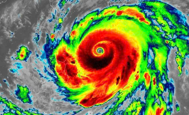
Super Typhoon Ragasa became the strongest storm on the planet in 2025, maintaining winds up to 270 km/h for a short period.
Super Typhoon Ragasa formed from a tropical depression on the evening of September 18 and intensified by nine categories over four days. The Northwest Pacific in 2024 recorded three super typhoons: Yagi, Gaemi, and Krathon. Among them, Yagi made landfall in Vietnam, causing high winds, landslides, flash floods, and inundation, resulting in 318 deaths, 26 missing persons, and damages nearing 84,000 billion VND.
According to forecasts, from October to December, the number of storms and tropical depressions in the East Sea will exceed the multi-year average, with more than four systems, of which two may make direct landfall.
ELEVATOR SAFETY BEFORE TYPHOON RAGASA (STORM NO. 9)
During the rainy and stormy season, ensuring elevator safety is critically important. Below are recommendations from experts at the Institute of Elevator Applied Technology to help residents prevent risks and ensure safe elevator use, as well as equipment maintenance:
- Do not use elevators when equipment is flooded or power is unstable: In conditions of storms, heavy rain, and flooding, absolutely avoid using elevators to ensure safety. Such situations can cause unstable power or short circuits, leading to elevators getting stuck mid-floor and endangering users.
At buildings and apartment complexes, management must assess the actual conditions, issue clear notices, and guide residents to prioritize safety.
- Move elevators to higher floors and disconnect power:
+ Relocate all elevator cabins to higher floors, ideally positioned midway in the shaft. This helps protect the cabin, counterweight, and cables from damage if water floods the pit at the bottom floor.
+ If the elevator has doors opening to the outdoors, move the cabin to the top floor to prevent water from seeping onto the cabin roof through gaps in outdoor-facing landing doors.
+ After relocating the cabin to a higher floor, immediately disconnect the power supply to halt elevator operations, preventing risks of electric shock and short circuits during flooding.
- After the storm ends:
+ Do not resume elevator use on your own.
+ Immediately contact professional elevator service providers to inspect the elevator's condition before restarting operations.


![[Photos] Impressions of Vietnam Elevator Expo 2025](https://media.tapchithangmay.vn/share/web/image/2026/1/mobi6703639038935945497270_350x210.webp "[Photos] Impressions of Vietnam Elevator Expo 2025")


